
Fishermans Bend Strategic Framework Plan released

After the release of the draft Fishermans Bend vision in September 2013, on Monday (28/07/14) the Planning Minister, Matthew Guy, announced the approval of the Fishermans Bend Strategic Framework Plan (FBSFP).
This will be the primary development guide throughout the four different Fishermans Bend precincts, which will eventually double the size of central Melbourne. Regular readers of Urban.com.au will be aware of the many different proposals that have already been lodged with the Minister's department (we have 14 of them on our Project Database) and in a press release Matthew Guy said:
Development of Fishermans Bend is a 40-year project but I have approved a limited number of permit applications that will allow some construction to start in the near future. Developers will be required to make financial contributions towards new infrastructure as part of their permit conditions.
Permit applications for land within the precinct would be assessed in the context of the Fishermans Bend SFP. The Metropolitan Planning Authority, which prepared the plan, will become the Responsible Authority for the precinct.
From October 1 the Metropolitan Planning Authority (MPA) will become the responsible authority for the receipt and determination of planning permits in the Fishermans Bend Urban Renewal Area.
Applicants are advised to liaise directly with the Central Cities unit of Planning Statutory Services in the Department of Transport, Planning and Local Infrastructure (DTPLI) about all current planning permit applications in Fishermans Bend.
Transitional arrangements ahead of 1 October 2014 will be agreed between prospective applicants, DTPLI and the MPA to determine the best course of action for forthcoming applications. The MPA will coordinate this transition.
Click any of the images for a full-screen view.

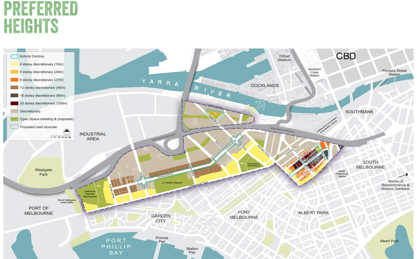
The current concentration of planning applications is overwhelmingly centred in the Montague precinct and as shown above, Montague is the area with the most diverse range of preferred discretionary height limits. In amongst the various maps throughout the document suite, Montague is shaded with a "rail investigation area" which correlates with the current Government's recent announcement to route the Melbourne Rail Link through the precinct.
Much of the sustainable transport vision from the Fishermans Bend Draft has been carried over to the FBSFP with Plummer and Fennell Streets forming a high-frequency transit corridor however one key feature has not been carried over: the 'potential future station' in Wirraway (page 39 of the draft). The FBSFB outlines a comprehensive network of trams and buses providing the main motorised sustainable transport services and the omission of the "Potential Future Station" in Wirraway originally seen in the draft vision raises questions on how much the PTV heavy rail plan has changed.
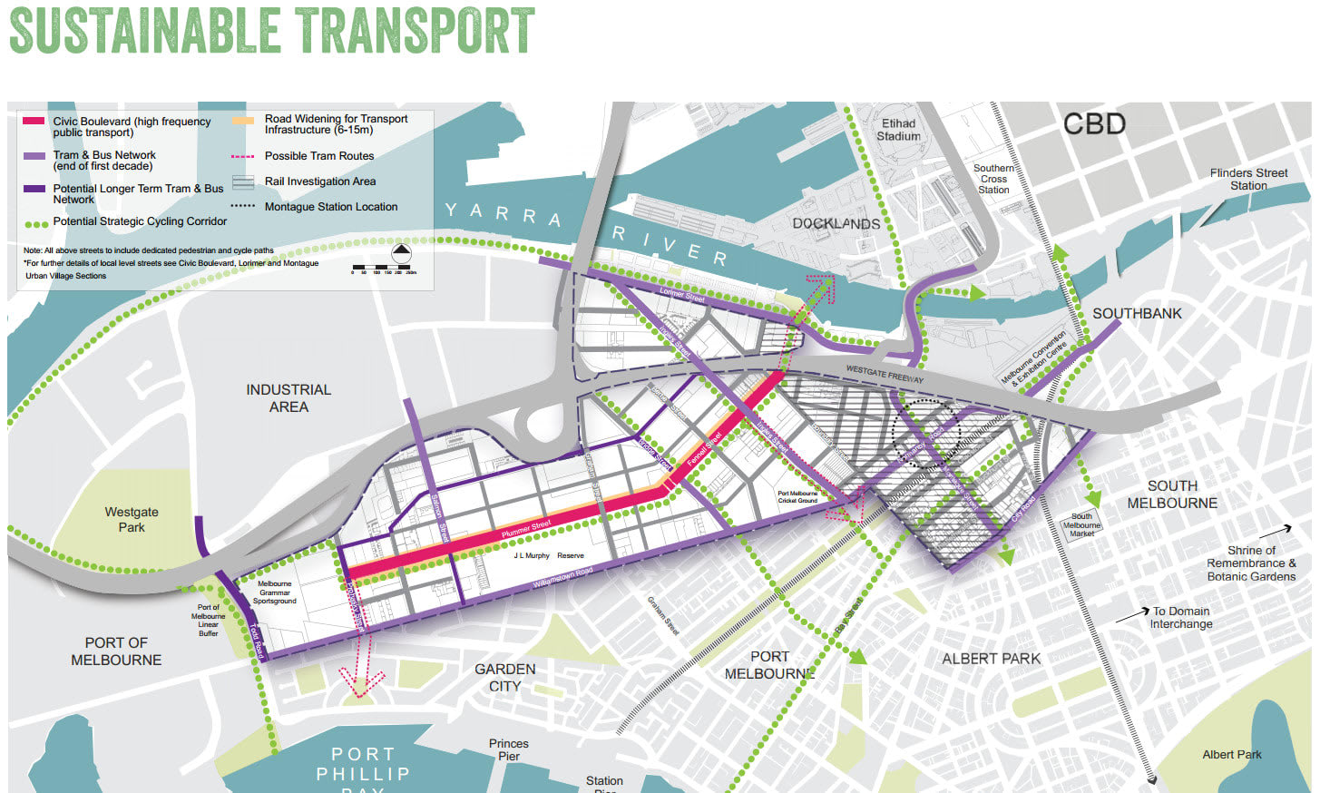
One aspect of the draft vision which may have been overlooked and now is quite prominent in the FBSFP (it is key element number 1) is the new street network envisioned for the Sandridge and Wirraway precincts. As the map below indicates, many existing streets and main roads through the entire renewal area will continue to function much as they do now (with a few exceptions such as the extra reservation for widened Plummer/Fennell Streets), however a new grid looks set to form on land that may currently have another use.
Land bankers beware?

Affordable housing does get a small mention in the land use considerations "affordable housing, including housing managed by Registered Housing Associations, will be strongly encouraged in Fishermans Bend to provide a diverse range of people with access to central city jobs, services and infrastructure. Flexible application of development contributions can be used to encourage affordable housing (see Design Guidance for further details)".
And the Design Guidance states under point 2.5 "Guideline 1: Most developments (over 20 dwellings) are expected to be designed to incorporate a mix of land uses and a diversity of residential typologies and dwelling sizes. Larger developments (over 200 dwellings) should consider including an affordable housing component".
Take from that what you will.
Click to view the FBSFP document suite on the MPA's website. Confused about precinct names? The Department of Transport, Planning and Local Infrastructure has a map on its website.
The Planning Minister's media release in full: