
Toying with ideas to improve Sydney Road

The City of Moreland at August's council's meeting has rejected a proposal to add what has been dubbed "anti-dooring" bike lanes on Sydney Road which would have seen painted bicycle lanes placed either side of the tram lanes. The council has reportedly voted to lobby the State government and VicRoads to investigate building separated bike lanes on the road instead.
Perfect timing.
While much of the media focus has been on bikes on Sydney Road - after the recent death of a cyclist after he was 'doored' and then flung out into the middle of the road and into the path of heavy vehicle - I'd argue Sydney Road actually needs a complete root and branch review of all of its uses.
The priority and focus, as with designing any street, should always be on the pedestrian. Sydney Road between Park Street in Brunswick and Bell Street in Coburg could best be characterised as having:
- narrow footpaths clogged with hodge-podge smatterings of street furniture, parking information polls and inconsistent surfaces
- ugly and inconsistent awnings hanging at various levels above the footpath
- next to zero greenery directly planted in the street
- far too many cars which in turn slows trams down; trams, the very vehicles that will easily carry more passengers (inside and outside of peak) compared to the litany of single-occupant vehicles holding them up.
According to a bicycle network / SKM report, in 2010 VicRoads installed 80cm wide bike lanes on Sydney Road which resulted in kerbside traffic lanes being reduced to a width of 3 metres. Tram traffic lanes measure 3.3m wide.
The kerbside traffic lanes currently have clearways governing them in both peaks: the southbound kerbside lanes of Sydney road have clearways in the morning peak and the northbound kerbside lanes have clearways in the afternoon peak.
Outside of weekday peak times, the kerbside lanes revert to spaces that allow cars to park on both sides of the street. This on-street parking, of course, is in addition to the enormous amount of off-street car parking as shown by some of the examples in the map below.
The areas which see the greatest economic activity - primarily through retail trade - located at the northern and southern extremities include vast open-air car parks and the precincts in between have a sprinkling of small car parks on both sides of the road.
A new Sydney Road?


The above was created using streetmix.net and is intended to be a cross-section looking south toward the city on Sydney Road. The features, or changes from the current allocation of space, are:
- Footpaths widened (utilising the 80 cm of space currently used to the quasi bike lanes VicRoads installed in 2010) and trees planted.
- The existing eastern (left side) kerbside lane is converted to a 3m width permanent two-way bike lane, 150cm of space for each direction.
- I chose the eastern side of Sydney Road simply because at the Park Street end it would naturally meet the existing shared bike path which runs all the way down to Melbourne University alongside Royal Parade.
- A short buffer is installed to separate the converted bike lane and the city bound tram/traffic lane.
- The tram lanes are still mixed tram/car traffic lanes and the western (right side) kerbside lane remains a parking and peak clearway much like how it currently operates.
This kind of set up would further discourage through traffic on Sydney Road in the morning peak (although, heavens knows why anyone would opt to use Sydney Road as a through route to the city in the first place…) yet still provides extra peak traffic capacity in the afternoon to use the route, functioning as an overflow route for the traffic which turns left from Royal Parade into Park St / Brunswick Rd heading to Citylink.
There's much greater emphasis on space for pedestrians and a proper bike lane set up through the heart of the municipality that would cater for both local cyclists and commuters alike. Commuter cyclists would be encouraged away from the Upfield bike path, which is currently shared with pedestrians.
Likewise the dedicated bike lanes would supercharge both the perception and reality of bike and pedestrian safety on Sydney Road thanks to complete separation of transport uses and coupled with extra bike parking facilities (thanks to the widened footpath) there's a greater incentive for people to travel to the entire strip.
After all, making a stand by turning a car sewer into a more pleasant urban environment will bring more people into the precinct thus creating more economic activity and flowing through to the retailer's bottom lines. Swanston Street, anyone?
While we're at it…
If the loss of morning peak traffic carrying capacity is just too much to bear for some (the people who would regularly troll comment threads with "cyclists should be licensed/pay registration"), perhaps implement the reverse on Lygon/Holmes/Nicholson Street; after all, this strip is and will continue to see just as much development density increases over time as Sydney Road.
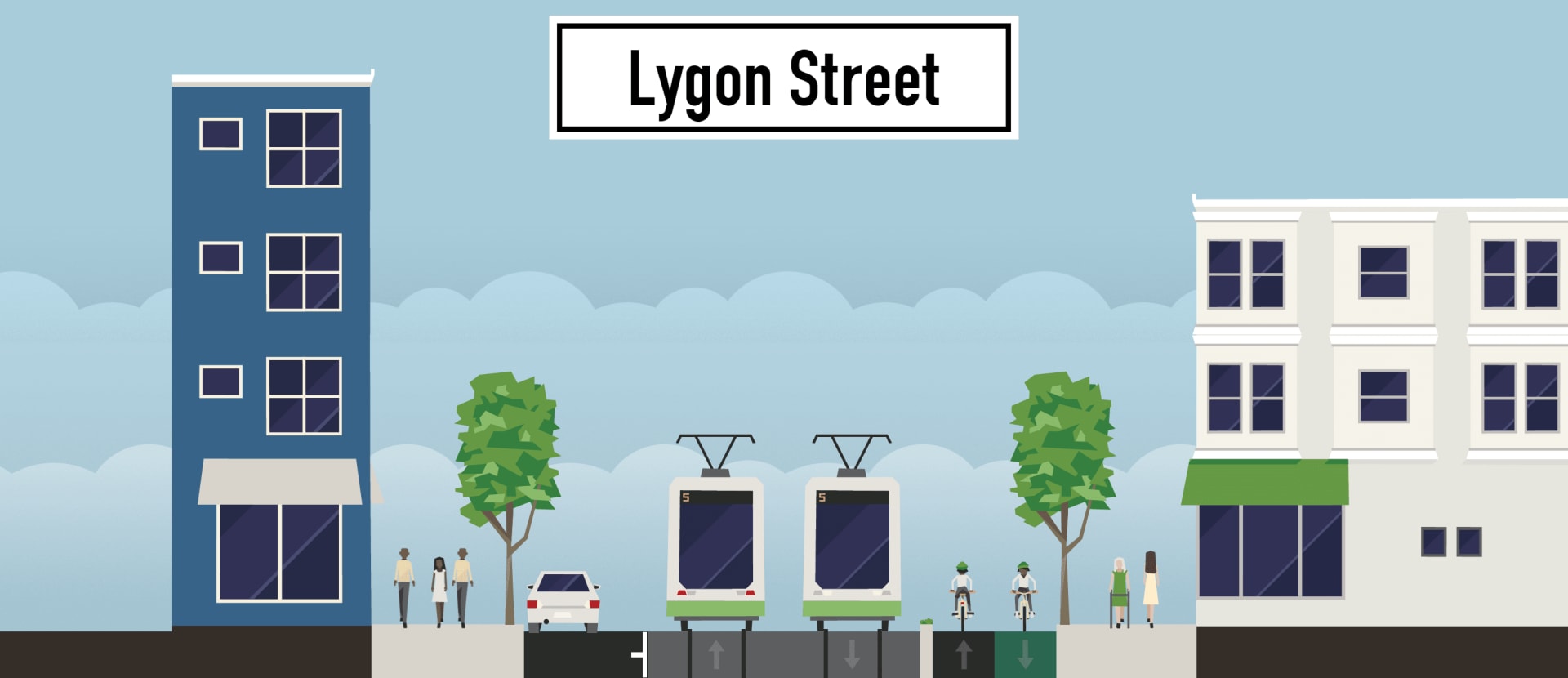
In this cross-section - the same as the Sydney Road one, we're looking south towards the city - exactly the same allocation of space to different transport modes applies except the converted bike lane is on the western (right) side of Lygon/Holmes/Nicholson Streets thus providing citybound clearways in the morning peak.
It then would fall with City of Melbourne to continue the bike infrastructure through their municipality. Having the two way bike lane on the western side of Royal Parade and the eastern side of Lygon Street would allow for the use of the wide path which skirts around Melbourne General Cemetery and Princes Park (extending the path out to the trees and if necessary reducing the amount of space available to pedestrians) thus funnelling bike traffic on to Swanston Street, which already has Copenhagen lanes.
Edit: Schooled
This is how you do a presentation! This is the document that was submitted to Moreland Council, the one Jonathan (first in the comments) is talking about from sydneyroad.org.
Jonathan also tells me that they polled retailers on Sydney Road and only 30% were opposed to the removal of on-street parking in order to widen footpaths and increase space for dining and displays.
The following is from the July meeting of Moreland council. Also check out Revitalising Sydney Road's facebook page.
Over to you
Tell us your ideas for Sydney Road (or the wider area) by posting in the comment section below.